Updates

Hiking Northern Arizona, 4th edition, 2021

Hike 24 map

Hike 21 SP Crater

SP Crater is closed to public access from January through May to protect golden eagle nesting sites. Hike 22, Colton Crater, doesn't appear to be affected by this seasonal closure, but please obey all signs and closure areas.

Hike 24 Bonito Crater

The Park Service no longer allows cross-country hiking within Sunset Crater National Monument, so this hike is no longer legal. In addition, the pull-off at the start of the hike is blocked by rocks. Here is an alternative hike:

Tags: 

Hiking Arizona's Superstition and Mazazal Country, 2nd Edition

New Cross F Trailhead map

Hike 35 Marion Spring- new trailhead location. The Cross-F Trailhead has been moved just south of the old location as described in Finding the Trailhead. From the old trailhead, continue south on the old highway less than 0.1 mile, then turn right (west) and drive less than 0.1 mile to the signed trailhead at the end of the road. The new trailhead was constructed by volunteers working with the Arizona Trail Association. GPS: N 33 54.534', W 111 29.232'

Tags: 

Hiking Nevada (Third Edition, 2017)

Hike 23 Hobart Lake: There is no longer a trailhead or parking as described. To reach the new trailhead, drive north on Nevada 28 to Incline Village, and park at Tunnel Creek Cafe. Walk south on Tunnel Creek Road to join the route as described just north of Tunnel Creek.

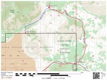
Hike 25 Marlette Lake: The trail on the road as described is now the mountain bike route (although you can still hike it). To avoid mountain bikes, you can start at the Spooner Summit Trailhead on US 50 east of the junction with Nevada 28, then hike the new Tahoe Rim Trail to Snow Valley Peak, then turn left on descend along a closed road to join the old road to Marlette Lake. Turn right to hike to the lake (this is the only segment of the route in the book.)

Hike 27 Mount Rose: The trail to Mount Rose has been rerouted and doesn't follow the road. From the trailhead at Mount Rose Summit, the trail climbs the southeast ridge of Tamarack Peak, then traverses the northeast slopes of the peak to join the original trail.

Tags: 

Explore! Joshua Tree National Park

On page 20, in the first paragraph under Geography and Geology, the second sentence should read "Most North American mountain ranges trend generally north and south, but the several ranges that are encompassed in Joshua Tree National Park run east to west, as do the ranges to the west, the San Bernadino and San Gabriel Mountains." (The San Jacinto Mountains are part of a north-south range that extends into Baja California.)

Tags: 

Wilson Mountain Trail, Hiking Northern Arizona

Hike 97, Wilson Mountain Trail, has been rerouted and is now 4.5 miles one-way, or 9.0 miles round-trip.

Tags: 

Exploring Great Basin National Park

Upper Lehman Campground is closed for renovation until summer 2017. Gray ClIffs Group Campground now has 11 tent campsites in addition to the group sites. You must reserve your site in advance at www.recreation.gov or by calling (877) 444-6777. Thanks to reader Doug Bauder for this update.

Tags: 

Creaky Knees Guide Arizona

Although the book's subtitle is "The 80 Best Easy Hikes", the hikes actually range from very easy to very difficult. This is also true of the other books in this series. Early in the design of the book, it became clear that trying to cover the entire state with just easy hikes would mean that some great hiking areas would be left out. After I looked through another book in the series (by a different author), I asked my editor if a range of hike difficulty should be included, and she said "Yes." So the word "Easy" should be dropped from the subtitle.

Tags: 

Best Loop Hikes Arizona

Hike 53 Deer Creek Loop

The trail past Paddy's River may be closed due to fire damage. Check with the US Forest Service office before planning this hike.

Grand Canyon Guide

Grand Canyon Guide: Your Complete Guide to the Grand Canyon (print edition), page 7

Grand Canyon Guide: Your Complete Guide to the Grand Canyon (Kindle edition), location 118

Grand Canyon National Park entrance fees will increase on June 1, 2015:

Basic Illustrated Using GPS, 3rd edition

The UTM coordinates of Aspen Spring on pages 24 and 25 do not agree. For reference, the coordinates as measured using ExpertGPS on the computer are 482189 mE 3816297 mN. On a map printed from ExpertGPS at 1:24000 using a 1:24000 corner grid reader (maptools.com), the coordinates are 482200 mE 3816300 mN, well within the accuracy limits of printed maps and civilian GPS (10 meters.)

Pages

Subscribe to Updates